

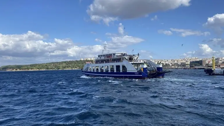
ÇANAKKALE, Turkey — Severe adverse weather conditions sweeping across the northern Aegean Sea have brought maritime transportation along key island routes in northwestern Turkey to a standstill. GESTAŞ, the primary maritime transport operator responsible for passenger and vehicle transit across the Çanakkale Strait and regional island lines, announced the complete suspension of all scheduled ferry sailings on both the Kabatepe-Gökçeada and Geyikli-Bozcaada routes due to an impending gale and hazardous sea conditions.
The announcement came after meteorologists warned of intensifying wind speeds and rough sea states across open stretches of the Aegean basin. According to reporting by Nazif Cemhan Şen of the Demirören News Agency (DHA), the transport authority confirmed that all ferrying operations connecting mainland Çanakkale to the off-shore islands of Gökçeada and Bozcaada were called off as a precautionary measure to ensure the safety of passengers, crew members, and vessels.
Complete Cancellation across Key North Aegean Island Routes
In an official public travel advisory released in Çanakkale, GESTAŞ Deniz Ulaşım A.Ş. stated that the decision to halt operations applies to all scheduled departures on both directions of the affected routes. The preemptive suspension directly impacts two of the busiest island transit corridors in the region: the line running between the Kabatepe ferry terminal on the Gallipoli Peninsula and the island of Gökçeada, as well as the line operating between the coastal mainland terminal at Geyikli and the island of Bozcaada.
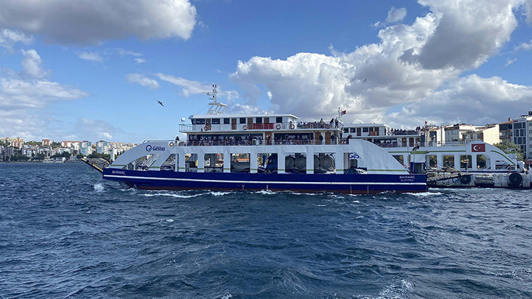
Maritime transportation officials emphasized that the severity of the expected storm system leaves no room for safe navigation or harbor docking maneuvers along these open-water routes. The complete cancellation means that no passenger or vehicular traffic will be accommodated on these specific corridors until weather conditions clear and maritime authorities determine that open-sea navigation can be resumed safely.
While transit within the more sheltered inner waters of the Çanakkale Strait (Dardanelles) often operates under different localized risk parameters, the routes extending outward into the northern Aegean Sea are far more vulnerable to rapid deterioration in weather. As a result, operations on the island lines were fully suspended ahead of the storm’s peak.
Geography of the Çanakkale Archipelago and Mainland Gateways
The two affected islands occupy strategic and culturally significant positions in the northern Aegean Sea, off the coast of Çanakkale province. Gökçeada, known historically as Imbros, is Turkey’s largest island and marks the westernmost point of the country. Situated near the mouth of the Saros Gulf, Gökçeada is separated from the mainland Gallipoli Peninsula by a broad expanse of deep water. The primary mainland transit hub for Gökçeada is the Kabatepe ferry pier, located within the boundaries of Eceabat district on the western shore of Gallipoli.
Further south lies Bozcaada, historically known as Tenedos, situated near the entrance of the Dardanelles and just off the coast of the ancient Troad region. Bozcaada is linked to mainland Anatolia primarily through the Geyikli ferry terminal, located in the Ezine district of Çanakkale. Though Bozcaada sits closer to the mainland coast than Gökçeada, the channel connecting Geyikli Pier to Bozcaada Harbor remains completely exposed to open Aegean winds and swell patterns.
Both islands represent unique municipal and geographic entities in Turkey, as their resident populations, local economies, and public services depend entirely on maritime links for day-to-day connectivity with the mainland. Because neither island possesses a fixed bridge or tunnel connection, ferry services operated by GESTAŞ function as the sole physical lifelines for motor vehicles, commercial freight, supply distribution, and passenger transit.
Meteorological Factors and Aegean Sea Hazards
The northern Aegean Sea is widely recognized by mariners and meteorologists for its volatile climatic behavior, particularly during seasonal transitions in autumn and winter. The region is frequently subjected to high-velocity wind patterns driven by atmospheric pressure differentials between Southeastern Europe, the Balkan Peninsula, and the broader Mediterranean basin.

The dominant wind forces in this part of the Aegean include the powerful northerly "Poyraz" winds and severe southerly "Lodos" gales. When these strong wind systems sweep down across the Aegean expanse, they build up deep wave troughs and high seas over relatively short durations. Unlike the narrow, land-bounded waters of the Çanakkale Strait—where surrounding hills and shoreline geography offer partial windbreaks—the sea channels leading out to Gökçeada and Bozcaada offer no terrain shelter.
Navigating car ferries across these open stretches during a high-wind event poses substantial operational hazards:
- High lateral wind pressures can affect vessel steering and cause significant rolling, increasing the risk of vehicle movement on car decks if seas become excessively rough.
- Large, breaking waves make maintaining a steady heading difficult for heavy displacement ferries.
- Strong crosswinds and heavy sea swells severely complicate harbor approach and docking procedures at both island piers, where narrow breakwater entrances require precise maneuvering.
- Physical impact risks to both vessel hulls and pier infrastructure rise dramatically when docking against heavy swells.
Ferry operators maintain strict operational limits regarding maximum wind velocity and wave height. When forecasted conditions exceed these safety parameters, standard maritime regulations mandate the suspension of service until conditions improve.

Impact on Island Infrastructure, Logistics, and Residents
The suspension of ferry service across both major island routes creates immediate operational challenges for residents, local businesses, municipal authorities, and regional supply networks. Daily life on Gökçeada and Bozcaada is intimately linked with the timing of ferry arrivals, which bring essential daily goods, fresh produce, commercial merchandise, mail, fuel, and medical supplies from mainland centers.
When weather systems force an abrupt shutdown of ferry links, local supply chains must temporarily rely on existing island inventories. Island merchants, agricultural producers, and municipal emergency services in both Gökçeada and Bozcaada routinely monitor maritime weather updates to prepare for potential multi-day isolations. Fuel transport tankers and heavy freight trucks bound for the islands often face extended delays at mainland staging areas near Geyikli and Kabatepe until sea conditions normalize.
The cancellation also disrupts personal travel for local commuters, public servants, healthcare workers, and tourists. Drivers planning to cross to or from the islands are frequently required to rearrange travel itineraries or wait at mainland port towns. Local law enforcement and municipal staff at Geyikli and Kabatepe often assist in managing traffic queues and informing stranded motorists when weather disruptions prolong terminal closures.

Healthcare logistics are another crucial consideration during severe weather shutdowns. While routine medical transport depends on scheduled ferry sailings, emergency medical transfers during full maritime suspensions require alternative coordination. In severe cases where medical evacuation is urgently required while ferries are grounded, regional emergency services liaise with coastal safety organizations, maritime rescue units, or air ambulance services, subject to flight safety conditions during the storm.
Operational Protocols and Resumption Outlook
GESTAŞ Deniz Ulaşım regularly updates its operational announcements through digital portals, text alert systems, and public notices at port terminals to keep travelers informed during weather-induced service disruptions. The company operates in close coordination with the Turkish State Meteorological Service (Meteoroloji Genel Müdürlüğü) and local port master authorities to monitor real-time atmospheric conditions, sea surface temperatures, wind vectors, and wave height metrics.
Under maritime protocols governed by national coast guard authorities and international maritime safety standards, vessel captains retain ultimate authority regarding departure decisions. Captains evaluate localized sea state conditions prior to any scheduled crossing, prioritizing the protection of human life and vessel integrity above adherence to timetable schedules.
Operations on the Kabatepe-Gökçeada and Geyikli-Bozcaada lines are expected to remain paused until the active storm system traverses the northern Aegean and sea conditions drop back below critical safety thresholds. GESTAŞ advised all prospective passengers and vehicle operators to check real-time service updates on the company’s official communication channels before traveling to harbor terminals in Kabatepe or Geyikli.